Deep Vision: How AI Processed 58,000 Seafloor Images in Ten Days to Map the Atlantic's Most Vulnerable Ecosystems
The Deep Vision project is using artificial intelligence to analyze over 58,000 deep-sea images in under ten days — a task that would take human analysts months — to create the first comprehensive maps of vulnerable marine ecosystems across the entire Atlantic basin, providing critical data for marine conservation and protected area designation.
Key Takeaways
The Deep Vision project uses AI to process 58,000+ seafloor images in under ten days, creating the first comprehensive maps of vulnerable marine ecosystems across the Atlantic basin. The initiative provides essential data for marine conservation and protected area designation, a task that would take human analysts months to complete.
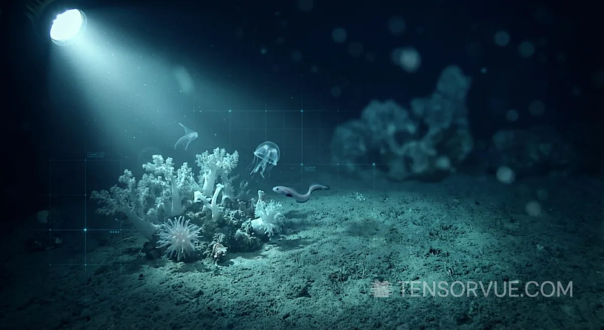
The deep ocean — Earth's largest and least explored habitat — remains one of the last frontiers of biological science. Over 80% of the ocean floor has never been mapped at high resolution, and the ecosystems it supports are understood only in fragments. But a new AI-powered initiative called Deep Vision, reported by Inside Ecology on March 8, 2026, is demonstrating that artificial intelligence can compress years of marine survey analysis into days.
The project has analyzed over 58,000 deep-sea images in fewer than ten days — a workload that would require a team of marine biologists months to complete manually. The result is the first attempt at comprehensive mapping of vulnerable marine ecosystems across the entire Atlantic basin, generating the kind of quantitative, spatially explicit data that policymakers need to designate marine protected areas and enforce conservation regulations.
The Scale Problem in Ocean Science
Remotely operated vehicles (ROVs) and towed camera systems have been collecting seafloor imagery for decades. But the volume of data they produce has overwhelmed the capacity of human analysts. A single ROV dive can generate thousands of high-resolution images and hours of video footage. Each image must be examined for species identification, habitat classification, substrate type, and signs of environmental disturbance — a process that requires specialist expertise and painstaking attention to detail. The result is a massive backlog: research institutions around the world hold terabytes of unanalyzed ocean imagery, representing years of lost scientific insight.
Deep Vision attacks this bottleneck directly. By training computer vision models on annotated seafloor imagery, the project has built AI systems capable of identifying species, classifying habitat types, and detecting vulnerable marine ecosystems — coral gardens, sponge fields, cold-water reefs, and hydrothermal vent communities — with accuracy that approaches expert human classification. The 58,000-image processing run represents a proof of concept that, if scaled to the full backlog of global ocean imagery, could transform marine conservation science.
From Data to Policy: Why Speed Matters
The urgency is not abstract. Deep-sea mining, bottom trawling, oil and gas exploration, and the laying of undersea cables are all expanding into deeper waters, often faster than science can assess the ecosystems they may disturb. International bodies such as the International Seabed Authority are actively deliberating mining regulations for the deep ocean, but the scientific data needed to inform these decisions — comprehensive maps of where vulnerable ecosystems actually exist — has been unavailable at the spatial scales required for effective policy.
Deep Vision is part of a broader ecosystem of AI tools for marine research. The Monterey Bay Aquarium Research Institute's FathomNet project has established an open-source image database specifically designed to train AI algorithms for ocean species identification. Deployable AI systems — compact, ruggedized hardware packages that enable AI-driven underwater vehicles to autonomously locate, track, and identify deep-sea animals in real time — are being tested for deployment on next-generation ROVs. Together, these initiatives are building the computational infrastructure that ocean science has lacked: the ability to turn raw imagery into actionable knowledge at the speed that conservation and resource management demand.
The implications extend beyond conservation. Understanding deep-sea ecosystems is fundamental to understanding the planet's carbon cycle, nutrient flows, and biodiversity resilience. The deep ocean is the world's largest carbon sink, and the organisms that inhabit it play roles in biogeochemical processes that affect the entire Earth system. AI-driven ocean mapping is not merely a technological convenience — it may be a prerequisite for informed stewardship of a planetary system whose most critical components remain largely invisible.
📚 Sources & References
| # | Source | Link |
|---|---|---|
| [1] | How AI could unlock deep-sea secrets of marine life |
|